
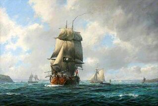
Endeavour in Pymouth Harbour by Greg Hunt
|
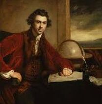
Sir Joseph Banks
|
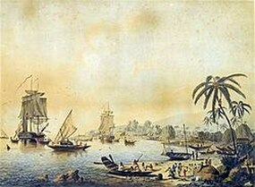
Ships in Matavai Bay, Tahiti
|
Cook departs on his first voyage of discovery
The voyage begins
Cook departed from Plymouth on 26 August 1768, carrying 94 people and 18 months of provisions. On 15 November, Endeavour reached Rio de Janeiro and stayed there until 2 December, re-provisioning and making repairs. The Viceroy, the Marques de Azambuja, had been warned by his Portuguese government that Britain was seeking to extend its overseas power and influence following its victory in the Seven Years' War. In his journal, Cook described Guanabara Bay, including its defensive fortifications, and noted that the city could be taken by a force of six ships of the line.
The ship rounded Cape Horn and continued westward across the Pacific to arrive at Matavai Bay, Tahiti, on 13 April 1769, where the observations were to be made of the transit which was scheduled to occur on 3 June. Cook commissioned the building of a fortified observatory on a sandy spit at the north-east end of Matavai Bay which he named Point Venus.
The primary purpose of the observation was to obtain measurements that could be used to calculate more accurately the distance of Venus from the Sun. If this could be achieved, then the distances of the other planets could be worked out, based on their orbits. On the day of the transit observation and, though their instrumentation was adequate by the standards of the time, the measurements were not accurate nor conclusive.
Aotearoa New Zealand
The observations complete after a three month stay, Cook then opened the sealed orders for the second part of his voyage: Acting on additional instructions from the British Admiralty, he was to search the south Pacific for signs of the southern continent of Terra Australia. The Royal Society believed that Terra Australis must exist and that Britain's best chance of discovering and claiming it before any rival European power would be by using Cook's innocuous Transit of Venus mission.
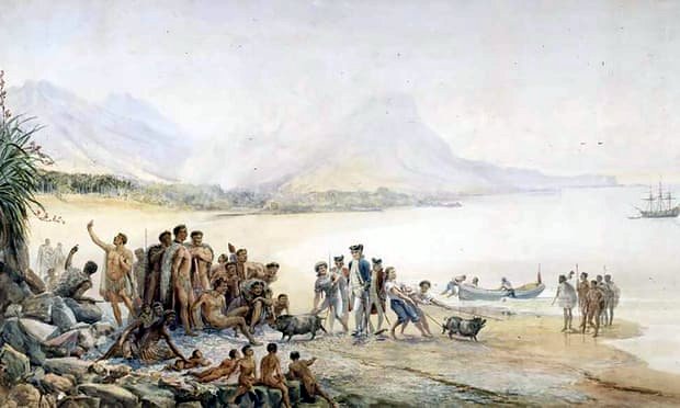
With the help of a Tahitian Aroi and navigator named Tupaia, who had extensive knowledge of Pacific geography, Cook reached Aotearoa New Zealand on 6 October 1769 - the second to sight these shores after Abel Tasman's explorations in 1642. Two days after arriving on-shore, they had their first encounters with some local Maoris which resulted in the death of several of their party. Cook's journal records that he regretted he had not been able to avoid hostilities.
Christmas was spent off the coast of the Northland, before navigating south along the West Coast without landing onshore. After two attempts to plant the British flag, with permission of one Maori chief, Cook hoisted the flag in the name of Crown and Country. The circumnavigation of the South Island was completed within two months. By the end of the complete journey around both islands of Aotearoa, Tupaia had recorded Māori oral histories; thousands of specimens were collected by Joseph Bank’s scientific expedition; and Cook had mapped the complete coastline.
Foveaux Strait - the enigma
Cook sighted Foveaux Strait during his circumnavigation of the South Island in March 1770 but as argued by author, Margaret Cameron-Ash, decided to hide it (see separate report on this debate). The Admiralty had issued its usual instructions to hide strategically important discoveries that could become security risks, such as off-shore islands from which operations could be mounted by a hostile power, such as France. Consequently, Cook amended both his journal and chart to depict Stewart Island (at the extreme south of the South Island, as a peninsula.
Cook Strait
On 22 January 1770, Cook climbed Kaitapeha peak on Arapawa Island and saw the strait (which he named Cook Strait) separating North and South Islands. This strait, which had been indicated in Abel Tasman's maps during his explorations in 1642, proved that New Zealand was an archipelago and not part of the imagined Southern Continent.
Instructions fulfilled
Cook wrote in his Journal on 31 March 1770 that "... It was therefore resolved to return by way of the East Indies by the following route: upon Leaving this Coast to steer to the Westward until we fall in with the East Coast of New Holland, and then to follow the direction of that Coast to the Northward, or what other direction it might take us, until we arrive at its Northern extremity; and if this should be found impracticable, then to endeavour to fall in with the Land or Islands discovered by Quiros”. (Pedro Fernandes de Queirós was a Portuguese navigator best known for his voyages of discovery of the Pacific Ocean in the service of Spain , in particular the 1595–1596 voyage.)
Sources: https://en.wikipedia.org/wiki/First_voyage_of_James_Cook#Preparations_and_personnel
Lying for the Admiralty Captain Cook's Endeavour Voyage by Margaret Cameron-Ash
Images sourced from the internet.
© Arthur Phillip Chapter of Fellowship of First Fleeters 2021-
The voyage begins
Cook departed from Plymouth on 26 August 1768, carrying 94 people and 18 months of provisions. On 15 November, Endeavour reached Rio de Janeiro and stayed there until 2 December, re-provisioning and making repairs. The Viceroy, the Marques de Azambuja, had been warned by his Portuguese government that Britain was seeking to extend its overseas power and influence following its victory in the Seven Years' War. In his journal, Cook described Guanabara Bay, including its defensive fortifications, and noted that the city could be taken by a force of six ships of the line.
The ship rounded Cape Horn and continued westward across the Pacific to arrive at Matavai Bay, Tahiti, on 13 April 1769, where the observations were to be made of the transit which was scheduled to occur on 3 June. Cook commissioned the building of a fortified observatory on a sandy spit at the north-east end of Matavai Bay which he named Point Venus.
The primary purpose of the observation was to obtain measurements that could be used to calculate more accurately the distance of Venus from the Sun. If this could be achieved, then the distances of the other planets could be worked out, based on their orbits. On the day of the transit observation and, though their instrumentation was adequate by the standards of the time, the measurements were not accurate nor conclusive.
Aotearoa New Zealand
The observations complete after a three month stay, Cook then opened the sealed orders for the second part of his voyage: Acting on additional instructions from the British Admiralty, he was to search the south Pacific for signs of the southern continent of Terra Australia. The Royal Society believed that Terra Australis must exist and that Britain's best chance of discovering and claiming it before any rival European power would be by using Cook's innocuous Transit of Venus mission.
With the help of a Tahitian Aroi and navigator named Tupaia, who had extensive knowledge of Pacific geography, Cook reached Aotearoa New Zealand on 6 October 1769 - the second to sight these shores after Abel Tasman's explorations in 1642. Two days after arriving on-shore, they had their first encounters with some local Maoris which resulted in the death of several of their party. Cook's journal records that he regretted he had not been able to avoid hostilities.
Christmas was spent off the coast of the Northland, before navigating south along the West Coast without landing onshore. After two attempts to plant the British flag, with permission of one Maori chief, Cook hoisted the flag in the name of Crown and Country. The circumnavigation of the South Island was completed within two months. By the end of the complete journey around both islands of Aotearoa, Tupaia had recorded Māori oral histories; thousands of specimens were collected by Joseph Bank’s scientific expedition; and Cook had mapped the complete coastline.
Foveaux Strait - the enigma
Cook sighted Foveaux Strait during his circumnavigation of the South Island in March 1770 but as argued by author, Margaret Cameron-Ash, decided to hide it (see separate report on this debate). The Admiralty had issued its usual instructions to hide strategically important discoveries that could become security risks, such as off-shore islands from which operations could be mounted by a hostile power, such as France. Consequently, Cook amended both his journal and chart to depict Stewart Island (at the extreme south of the South Island, as a peninsula.
Cook Strait
On 22 January 1770, Cook climbed Kaitapeha peak on Arapawa Island and saw the strait (which he named Cook Strait) separating North and South Islands. This strait, which had been indicated in Abel Tasman's maps during his explorations in 1642, proved that New Zealand was an archipelago and not part of the imagined Southern Continent.
Instructions fulfilled
Cook wrote in his Journal on 31 March 1770 that "... It was therefore resolved to return by way of the East Indies by the following route: upon Leaving this Coast to steer to the Westward until we fall in with the East Coast of New Holland, and then to follow the direction of that Coast to the Northward, or what other direction it might take us, until we arrive at its Northern extremity; and if this should be found impracticable, then to endeavour to fall in with the Land or Islands discovered by Quiros”. (Pedro Fernandes de Queirós was a Portuguese navigator best known for his voyages of discovery of the Pacific Ocean in the service of Spain , in particular the 1595–1596 voyage.)
Sources: https://en.wikipedia.org/wiki/First_voyage_of_James_Cook#Preparations_and_personnel
Lying for the Admiralty Captain Cook's Endeavour Voyage by Margaret Cameron-Ash
Images sourced from the internet.
© Arthur Phillip Chapter of Fellowship of First Fleeters 2021-
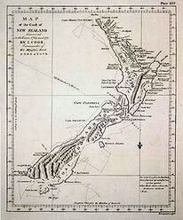
Captain Cook's map of New Zealand
|
Cook's party landing in New Zealand
|
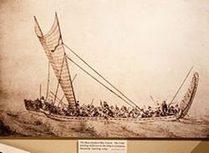
Māori war canoe with triangle sail drawn by Herman Spöring during Cook's first voyage
|
